The Nazca lines of Peru are famous geoglyphs, constructed in the arid deserts of south-central coastal Peru between about 500 BCE and 500 CE. Hundreds of straight, spiral, or meandering lines; geometric shapes; and over 70 animal forms, including monkey, spider, whale, hummingbird, and others, plus trees and flowers, cover the desert floor and hill slopes. Ancient people made these enormous designs by scraping away dark, iron oxide coated surface layers of gravel to expose light-colored soil.
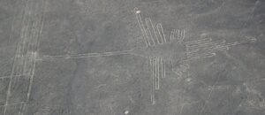
Nazca hummingbird geoglyph (Wikimedia)
Geoglyphs are defined as large designs typically longer than about 13 feet (4 m) and produced on the ground by arranging rocks or soil. This type of land art is a distinctive element of the archaeological record along the Pacific coast of the Americas, from California to Chile, best preserved in stable, arid environments. In South America, the Paracas and Nazca cultures created the most numerous and complex designs. In North America, geoglyphs are found in the desert regions along the lower Colorado River in California and Arizona, along the lower Gila River in southwestern Arizona, southwest into Baja California, Mexico, and into the Sierra Pinacate of Sonora, Mexico.
Archaeologists have been studying this ancient artwork for decades. In some regions, geoglyphs seem to have evolved from older petroglyph traditions by transferring common motifs from rock surfaces to ground surfaces. Understanding why they were made is more elusive, and it is likely that over the centuries that people constructed these features, their motives changed. When the ancient ones shaped the geoglyphs is also uncertain. Attempts to date directly the rocks exposed during construction have so far been unreliable, so comparing the images to other artifacts, and cross-dating ceramics that can be associated with them, are the most important ways for making age estimates.
Nazca and Atacama Desert Geoglyphs
The first published mention of the Nazca lines was in 1553 by Pedro Cieza de Leon, a Spanish conquistador and chronicler, only a few decades after Francisco Pizarro and his army invaded the Andes. Archaeologists began studying them in the mid-1900s. Aircraft, from spacecraft to drones, are valuable for identifying and mapping many of these figures.
The Paracas culture, which flourished in the southern coastal deserts of modern Peru between about 700 BCE and 100 BCE, may have been the first Andeans to experiment with making massive geoglyphs. Artists placed many of these on hillsides, so they were visible to people in villages or travelers below. Human figures, some with headdresses and interpreted as warriors, as well as animals, lines and geometric figures were made. Paracas people built stone platforms on hills or along plateau edges that overlook geoglyphs in valleys. Lines fan outward from some platforms, suggesting these sites were places for offerings and gatherings. Some Paracas geoglyphs in remote locations have heavily compacted surfaces where many people apparently walked and also left ceramic vessels on or around the lines. New geoglyphs were built crossing or covering older ones, suggesting that geoglyph construction was an important social activity.
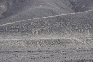
Paracas geoglyphs named “The Family” (Wikimedia)
The Nazca culture that dominated the southern coast of modern Peru from about 100 BCE to 700 CE began constructing geoglyphs several centuries after the Paracas, and in the same general region. Most Nazca geoglyphs are on the flat desert floor and had to be viewed from surrounding high terrain. The largest of the Nazca geoglyphs are about 1200 ft (370 m) long, with the hummingbird 105 ft (93 m). Lines are typically 4 to 6 inches (10 to 15 cm) deep, with a width of around 13 in (33 cm), although this can vary and some lines are 6 ft (1.8 m) wide.
In creating the wide variety of forms, Nazca artists typically used a continuous line in the design. The deserts where they constructed these shapes are among the driest on Earth, in the rain shadow of the Andes Mountains. Calcium in the desert soils, combined with the ocean mists that regularly cover the region, hardened to protect the designs from erosion, enhancing their preservation.
Why ancient people created such complex features in deserts has fascinated people for centuries. Theories on the cultural meaning and function of geoglyphs range from the practical to the ritualistic. Some geoglyphs have astronomical and calendrical alignments, such as lines aligned along the directions of the solstices and equinoxes, and these may have assisted in the timing to plant and harvest crops. Other geoglyphs were likely associated with the availability of water, a precious resource in the desert. Some lines follow the paths of groundwater flow and show the locations of wells. Religious practices had an important role, and social cohesion may have been strengthened when people gathered to build the geoglyphs or perform rituals associated with them.
Geoglyphs in California
In the Colorado Desert, close to the border between California and Arizona, a set of giant figures are known as the Blythe Geoglyphs (about 15 mi/24 km north of Blythe and west of U.S. Highway 95 near the Colorado River). Three human figures and two four-legged animals are part of the group, with the largest human figure measuring 171 ft (52 m) long. The age of these figures and the identity of the creators is uncertain, but they could be at least 1,000 years old. The U.S. Bureau of Land Management erected fences to protect the geoglyphs in 1974.
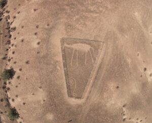
Blythe geoglyphs (Wikipedia)
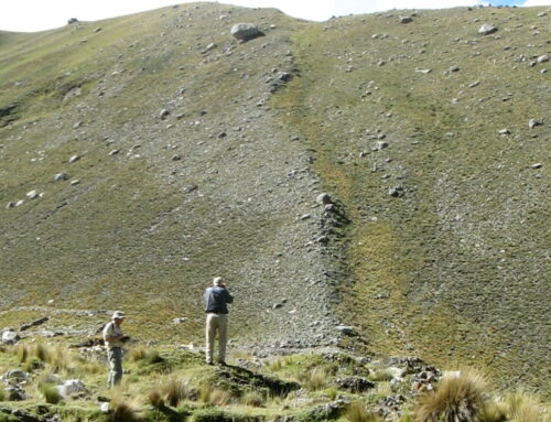
Another site near Needles, called Topock Maze, has been considered by many to be a Native American geoglyph site, although it almost certainly is not. A few years ago, I visited this site and was impressed by the uniformly scraped rows of gravel that contoured the landscape (there is no maze, so the name is not accurate). At that time, I assumed that the pattern represented a geoglyph. The site is a protected archaeological site and listed on the National Register of Historic Places.
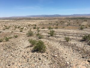
Topock lines near Needles, California, with Colorado River visible in upper left corner (my photo)
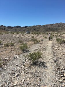
Topock lines (my photo)
Detailed investigations of these lines by an archaeologist (Musser-Lopez, 2011), however, presents compelling evidence that they are unrelated to the Blythe Geoglyphs. Instead, construction workers shaped the rows in the 1880s as part of horse-drawn mechanical gravel harvesting while building nearby railroad tracks. Information presented in the paper convinced me that these scraped lines are of recent origin. Particularly convincing data are from photographs taken in 1908 and then at approximately the same location in 2011, that clearly show the rows were much more compact and uniform in the older photograph.
Traditions of the Americas
Indigenous people marking their landscapes have a long history in the Americas. In the Andes Mountains, this culminated in the ceque lines of the Incas — a ritual setting of physical and imaginary lines radiating outward from the capital city of Cusco to the edges of the empire. Each of the lines connected a dozen or more deeply symbolic shrines, called huacas, which included hills, caves, temples, springs, ravines, rock outcrops, mountain summits and passes, and many other natural and constructed features. They were the places where the Incas made offerings to deities and performed sacrifices during rituals.
Geoglyphs provide us with a glimpse into the world of the ancient people who made them. We will never understand fully the meaning of these symbols, but they are fascinating indicators of the richness and complexity of the worlds of indigenous Americans.
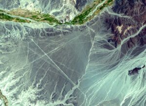
Nazca lines from space (Wikimedia)
If you liked this post, please share it and/or leave a comment or question below and I will reply – thanks! And if you’d like to receive a message when I publish a new post, scroll down to the bottom of this page and leave your email address on my website. Join now to learn more about geology, geography, culture, and history.


.jpg)
Great article! I’ve always been fascinated with these.
Note that Barcelona’s Eixample could fit the description of a geoglyph, albeit a more complex one:
https://images.app.goo.gl/heZb1ndaR18A9h2MA
Viewed from above it’s also fascinating.
As to why they built these, the reason is probably similar to what drove the Catalans to construct the Eixample around the Sagrada Familia – art, beauty and a search for sacredness, all values that are in decline in our current society.
Thanks, Leo! Very interesting pattern — and unfamiliar to me, although I have visited the amazing Sagrada Familia. I appreciate your comment and the link!
Another one of your great pieces I greatly enjoyed, Roseanne.
Thank you, Karen!