When an M8.2 earthquake struck offshore south of the Alaska Peninsula on July 28, 2021, the eerie sound of sirens warning of a possible tsunami sent people along the coast scrambling for higher ground. Authorities lifted the warning within a few hours, and damage from ground shaking was limited. So, although the earthquake certainly provoked anxiety among local citizens who may have initially feared the worst, viewed from a broader perspective, we can consider it a minor distraction. Many earthquakes that are this powerful result in major disasters.
Scientists typically define great earthquakes as those of M8.0 and greater, although some definitions place the lower limit at M7.5. These are ENORMOUS earthquakes! Lands surrounding the Pacific Ocean — the Pacific Ring of Fire — are the most likely to produce great earthquakes, as they are typically near the edges of oceanic plates and associated with subduction zones. We can relate the degree of damage caused by these events to earthquake characteristics, including type and extent of fault movement, as well as proximity to populated areas.
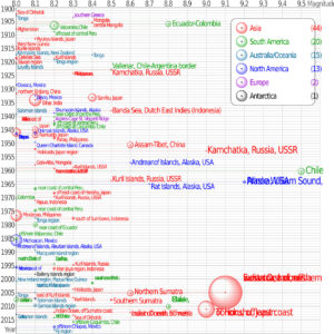
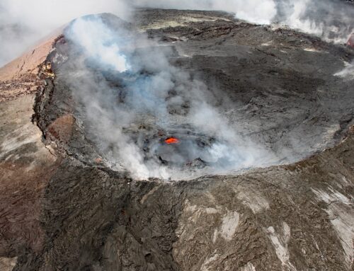
Earthquakes of magnitude 8.0 and greater from 1900 to 2018. The apparent 3D volumes of the bubbles are linearly proportional to their respective fatalities; USGS data (Wikipedia) (Note: large circles with garbled labels in lower right corner are “Prince William Sound, Alaska, USA”, “Indian Ocean, off west coast of northern Sumatra, Indonesia” and “Tohoku, off east coast of Honshu, Japan”)
Subduction zones are the frequent source of great earthquakes. As a tectonic plate of oceanic crust dives downward, it pulls the leading edge of the overlying continental plate along with it. This enormous strain eventually exceeds the strength of the rock, which then ruptures in an earthquake. We can relate some great earthquakes to other types of plate motion; the largest ones within the past century have been due to the collision of India with Asia, which is pushing the Himalayas to greater heights.
Other great earthquakes are associated with zones of weakness attributed to active or failed rift zones. In North America, most notable is the New Madrid Seismic Zone, which spans the intersection of Missouri, Kentucky, Tennessee and Arkansas. This zone produced four large earthquakes, with two having magnitudes that scientists estimate at M7.5, between December 1811 and February 1812. The region was only sparsely populated, but there was widespread damage to structures. Many trees were knocked down and riverbanks collapsed. The earthquakes are noteworthy for ringing church bells in Richmond, Virginia, approximately 800 miles (1287 km) distant and shaking windows in Washington, DC. Scientists attribute the active faults in the New Madrid region to the Reelfoot Rift. This roughly 750-million-year-old rift system failed to split the continent but created a zone of weakness in the Earth’s crust that is the source of ongoing earthquake activity. (More about rifts in my post: Rifts and the Rio Grande)
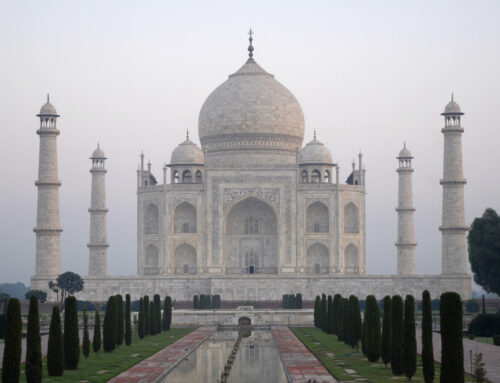
There have been five earthquakes of M9 and larger in the past century. Shown on the map below, these occurred in 1952 in Kamchatka, Russia; 1960 near Valdivia, Chile; 1964 near Anchorage, Alaska; 2004 near northern Sumatra; and 2011 near Honshu, Japan. These giant earthquakes are so fascinating that I may write a future blog post focused only on them. (Disclosure: I evaluated earthquake hazards for decades during my professional career–so yeah—unusual earthquake behavior is intriguing!)
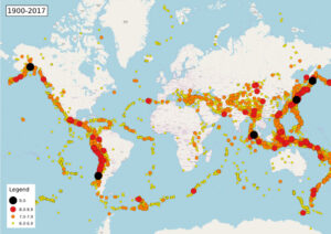
Map of earthquakes 1900-2017, consisting of 9.0-: 5 earthquakes; 8.0-8.9: 88 earthquakes; 7.0-7.9: 1,260 earthquakes; 6.0-6.9: 9,742 earthquakes; Total: 11,095 earthquakes; USGS earthquake archives (Wikimedia)
Tsunamis Traveling for Thousands of Miles
Great earthquakes also frequently trigger tsunami waves that can travel for thousands of miles across oceans before smashing into locations far from the earthquake origin. Most take place in the Pacific Ocean, generated from earthquakes on the subduction zones in the Ring of Fire. Submarine landslides, volcanic explosions, and glacier calving can also cause tsunamis. Along the South American coast, the earthquake record since 1562 shows that a tsunami has accompanied about half of all the recorded great earthquakes.
The astonishingly deadly power of tsunamis was demonstrated to the world in the catastrophic subduction zone-generated Sumatra-Andaman earthquake of December 2004. Originating near the northern tip of Sumatra in Indonesia, this magnitude 9.1 earthquake generated tsunami waves up to 100 feet high that overwhelmed coastal communities around the Indian Ocean. The number of fatalities, with over 230,000 perishing, is truly staggering.
Tsunamis are essentially large stacks of water. We know they are caused by the same mechanism that triggers subduction zone earthquakes — a leading edge of an overriding continental crust is dragged downwards until it finally breaks free and springs upwards. This has the effect of raising the elevation of the seafloor; water then forms a mound above it, since fluids are incompressible. Gravity instantly acts to level the mound of water, in the process setting up an oscillating wave that can travel outward at speeds of 500 miles per hour, comparable to commercial jetliners.
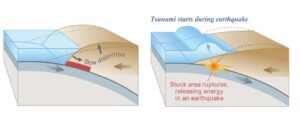
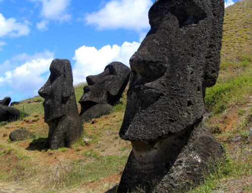
Diagrams of vertical slice through a subduction zone; over-riding plate bulges under strain, causing tectonic uplift–then, plate slips in an earthquake and releases energy into the water, resulting in a tsunami (USGS)
In the deep water of the open ocean, a tsunami wave height may be so low as to be unnoticeable. As the seafloor shallows approaching a shoreline, however, the wave speed decreases. Conservation of energy requires the advancing wave front to steepen and so water piles up, creating a towering wave that grows in height until it finally breaks on land. The devastating effects of tsunamis result from both the smashing force of a massive wall of water and the powerful effect of a large volume of water draining back seaward while picking up and carrying debris. For as long as people have inhabited the coastal regions around the Pacific Ocean, damaging tsunamis have wreaked havoc on their communities.
Earthquake Excitement in Alaska
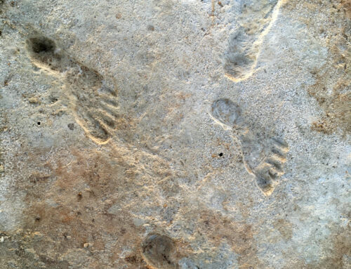
Alaska is the most tectonically active region of the United States and scientists have recorded a very high density of large earthquakes along the Alaska Peninsula. The M8.2 earthquake in July 2021, now known as the Chignik Earthquake, ruptured roughly the same area as an M8.3 earthquake in 1938–this location is near the edge of the eastern third of the peninsula shown on the map below.
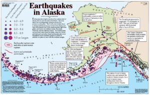
Map showing tectonic setting and distribution of earthquakes in Alaska, USGS
The Chignik Earthquake struck at 10:15 pm local time on Wednesday, July 28,2021 (6:15 am July 29 GMT) and did relatively little damage, with reports of moderate shaking in Perryville about 65 miles (105 km) to the northwest and weak to light shaking in Anchorage, about 490 miles (792 km) to the northeast. Ocean waves up to about a foot in height hit Kodiak Island and other coastal areas, but no damage was reported.
The earthquake originated about 50 miles south of the Alaska Peninsula and resulted from thrust faulting on or near the subduction zone interface between the Pacific and North American plates. In this region, the Pacific plate is pushing north-westward and plunging beneath the continental North American plate with a convergence rate of about 2.5 inches/year (64 mm/year), roughly the rate at which our fingernails grow. Large earthquakes are common in this region, including M7.8 and M7.6 events in 2020 that were both within about 90 miles (145 km) of the July 2021 earthquake (now considered foreshocks). As mentioned above, the Chignik Earthquake was in the same area as an M8.2 earthquake in 1938.
Earthquakes that are mere distractions — like the July 2021 Chignik Earthquake — are good reminders that we need to be prepared for more damaging ones. The next great earthquake — whether in Alaska or Asia or anywhere else in the world — could be disastrous.
Please share this post! Also, please scroll down to the bottom of this page and leave your email address on my website. You’ll receive messages only when I publish a new post (about once a week) and my occasional newsletter. Join now to learn more about geology, geography, culture, and history.

Oh my, Roseanne, your earthquake aficionados will be in heaven with your graphs and charts.
Reminds me that a museum in Aukland, New Zealand, has a room that approximates the shaking and sounds of an earthquake.
I couldn’t wait to get out of it!
Thanks Karen! Yeah, earthquakes aren’t much fun — especially because you don’t know when the shaking will stop!
My son just moved to Kodiak AK with the Coast Guard. The Chignik earthquake scared him a lot! The locals say quakes are common, but it really freaked him out. He plans a “go bag” for the next time.
Earthquakes are frightening — they are powerful forces over which we have absolutely no control! Thanks for the comment, Janice.
Dear Roseanne,
I am thoroughly enjoying your blogs.
THANK YOU!. I learned and certainly expanded my knowledge about earthquakes. Your information and images
helped me understand better and visualize
what physically occurs to cause earthquakes and tsunamis. Robin’s and my brother Lee was at a restaurant in Indonesia the day before a tsunami wiped
it and the entire coastal area there OUT.
Good timing for Lee, but so sad for the folks who couldn’t get to higher ground.
Thanks for this note, Eden. Very fortunate for Lee — and a very scary near-miss. Yikes. Such a tragic event for so many.